N37 37.662 W76 32.696 - First marker
N37 37.512 W76 33.025 - Inside the seawall
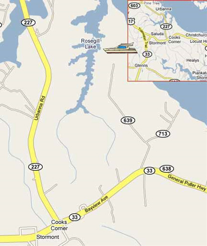
Driving Directions
From North. Follow Route 17 South. Turn left onto Route 33 East in Saluda. Go 3 miles on Route 33 East. Turn left at Route 639 (Crafton Quarter Road), which parallels Christchurch School. Follow 639 to the end and continue straight when it turns into a gravel road. Follow the gravel road towards the river. The boatel will be visible on the right.
From South. Follow Route 17 North. Turn right onto Route 33 East in Saluda. Go 3 miles on Route 33 East. Turn left at Route 639 (Crafton Quarter Road), which parallels Christchurch School. Follow 639 to the end and continue straight when it turns into a gravel road. Follow the gravel road towards the river. The boatel will be visible on the right.
From West. Take I-64 east towards Norfolk/Williamsburg. Take exit #220/VA-33 East. Go through West Point and continue on Route 33 East. Turn left on Route 17 North in Glenns. Go 2 miles and turn right onto Route 33 East in Saluda. Go 3 miles on 33 East. Turn left at Route 639 (Crafton Quarter Road), which parallels Christchurch School. Follow 639 to the end and continue straight when it turns into a gravel road. Follow the gravel road towards the river. The boatel will be visible on the right.
From East. Follow Route 33 West. Turn right at Route 639 (Crafton Quarter Road), which parallels Christchurch School. Follow 639 to the end and continue straight when it turns into a gravel road. Follow the gravel road towards the river. The boatel's roof will be visible on the right.
Google Maps